Particracy Forum
Colonial register
44 posts • Page 3 of 5 • 1, 2, 3, 4, 5
Re: Colonial register
![]() by Liu Che/Zhuli » Fri Dec 27, 2013 1:46 pm
by Liu Che/Zhuli » Fri Dec 27, 2013 1:46 pm
When I was a Moderator, JBN and I decided, on the advice of Darvian, that New Englia should be removed from the game as it was not controlled by a single country, as was the rule at that time according to the Pax Cynica. However, since that document is dead, what exactly is the status of New Englia? Reinstated as an independent colony? If so, does this mean independence can be granted to the colonies without colonization by other nations? If not, then must New Englia be colonized by a country?

-
Liu Che/Zhuli - Posts: 1261
- Joined: Tue Aug 03, 2010 10:41 pm
- Location: Indrala (P1) Jing (P3)
Re: Colonial register
![]() by Afrocentric » Fri Dec 27, 2013 2:18 pm
by Afrocentric » Fri Dec 27, 2013 2:18 pm
New Englia was granted independence by Kirlawa when it still had possession of it. As far as I'm concerned, it should be an independent nation that no player or country is allowed to control.


Urban Party of Kirlawa, Kirlawa - Inactive
Democratic Reform Party, Talmoria - Inactive
Labour Party, Saridan - Inactive
Urban Party of Rutania, Rutania - Inactive
http://www.soundcloud.com/djtechnotikofficial
-

Afrocentric - Posts: 2377
- Joined: Mon Apr 27, 2009 1:20 am
- Location: Maryland / Rutania
Re: Colonial register
![]() by MichaelReilly » Fri Dec 27, 2013 3:05 pm
by MichaelReilly » Fri Dec 27, 2013 3:05 pm
Afrocentric wrote:New Englia was granted independence by Kirlawa when it still had possession of it. As far as I'm concerned, it should be an independent nation that no player or country is allowed to control.
This.
Down with this sort of thing
-

MichaelReilly - Posts: 1130
- Joined: Sat Apr 10, 2010 8:39 pm
- Location: The boy from the County Hell
Re: Colonial register
![]() by PaleRider » Fri Dec 27, 2013 5:40 pm
by PaleRider » Fri Dec 27, 2013 5:40 pm
So New Eglia is up for grabs?
Political Affiliation~ GOP (US)
Pro: Liberal Conservatism, Paleo-liberalism, Chicago Capitalism, social conservatism, neoconservative
Anti: leftist, multiculturalism, Islamic radicalism
Currently the Zardic People's Party
Starring as Wiendonia in NS
Pro: Liberal Conservatism, Paleo-liberalism, Chicago Capitalism, social conservatism, neoconservative
Anti: leftist, multiculturalism, Islamic radicalism
Currently the Zardic People's Party
Starring as Wiendonia in NS
- PaleRider
- Posts: 1388
- Joined: Tue Jul 10, 2012 1:26 am
Re: Colonial register
![]() by Afrocentric » Fri Dec 27, 2013 8:58 pm
by Afrocentric » Fri Dec 27, 2013 8:58 pm
Hopefully not.
Urban Party of Kirlawa, Kirlawa - Inactive
Democratic Reform Party, Talmoria - Inactive
Labour Party, Saridan - Inactive
Urban Party of Rutania, Rutania - Inactive
http://www.soundcloud.com/djtechnotikofficial
-
Afrocentric - Posts: 2377
- Joined: Mon Apr 27, 2009 1:20 am
- Location: Maryland / Rutania
Re: Colonial register
![]() by Farsun » Thu Jan 09, 2014 7:53 pm
by Farsun » Thu Jan 09, 2014 7:53 pm
Any word on this or the status of a map?
Dorvish Social Nationalist Party
OOC Administrator of the Artanian Union & Bureaucrat of the Particracy Wiki
OOC Administrator of the Artanian Union & Bureaucrat of the Particracy Wiki
- Farsun
- Posts: 2113
- Joined: Wed Jun 23, 2010 7:47 pm
- Location: New York, United States.
Re: Colonial register
![]() by Amazeroth » Fri Jan 10, 2014 2:23 pm
by Amazeroth » Fri Jan 10, 2014 2:23 pm
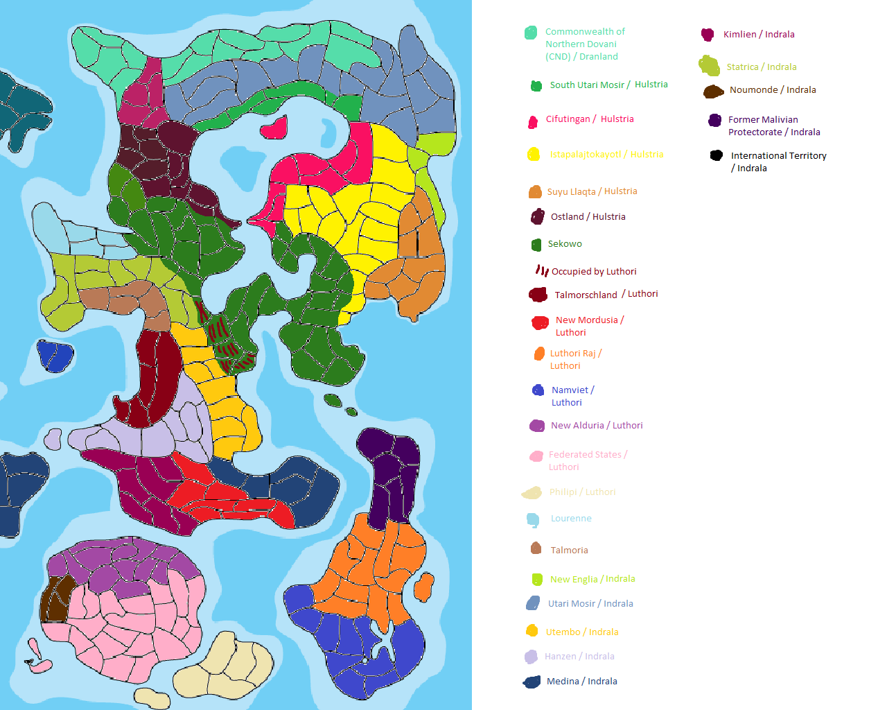
This is where I am so far. White means that the region is split between two countries, black means that it's unclear who the region belongs to. Grey are the areas nobody here has claimed to own. Since nobody from Malivia and Alduria has claimed to their colonies, they will revert to unclaimed, and be up for grabs. The same goes for New Englia, which has since been claimed by Indrala, if I'm not mistaken (and will be declared as such in the final version of the map). I have no idea who the region between Lourenne and Talmoria (referred to as "Statrica" by MichaelReilly's map) belongs to, but if there's no good reason it wasn't claimed, it will be free too.
Please confirm if the map is right, point out mistakes, and explain who owns the tiny island next to the small island belonging to the Federated States (in the South-West).
Don't worry about the white regions, I'll fill them in according to the maps I've recieved, and there are no contradictions there. Sorry if the Indralan colonies are somehow incorrect, but Liu's image is missing.
Eines Tages traf Karl der Große eine alte Frau.
"Guten Tag, alte Frau", sagte Karl der Große.
"Guten Tag, Karl der Große", sagte die alte Frau.
Solche und ähnliche Geschichten erzählt man sich über die Leutseligkeit Karls des Großen.
"Guten Tag, alte Frau", sagte Karl der Große.
"Guten Tag, Karl der Große", sagte die alte Frau.
Solche und ähnliche Geschichten erzählt man sich über die Leutseligkeit Karls des Großen.
-

Amazeroth - Posts: 4169
- Joined: Wed Apr 08, 2009 11:28 pm
- Location: Central Europe
Re: Colonial register
![]() by Polites » Fri Jan 10, 2014 2:51 pm
by Polites » Fri Jan 10, 2014 2:51 pm
I'm pretty sure that you mean Hulstria & Gao-Soto and not Hutori as the colonial owner of South Utari Mosir, Cifutingan, Istapalajatokayotl, Suyu Llaqta, and Ostland.
Concerning the black region, I seem to have made a mistake when I drew the map of Hulstria's colonies, that region should be Sekowo's (this accurately shows the border between Hulstrian and Sekowan colonies)
Concerning the black region, I seem to have made a mistake when I drew the map of Hulstria's colonies, that region should be Sekowo's (this accurately shows the border between Hulstrian and Sekowan colonies)
- Polites
- Posts: 3198
- Joined: Tue May 11, 2010 3:48 pm
Re: Colonial register
![]() by Amazeroth » Fri Jan 10, 2014 3:50 pm
by Amazeroth » Fri Jan 10, 2014 3:50 pm
Thanks. I've updated the map.
Eines Tages traf Karl der Große eine alte Frau.
"Guten Tag, alte Frau", sagte Karl der Große.
"Guten Tag, Karl der Große", sagte die alte Frau.
Solche und ähnliche Geschichten erzählt man sich über die Leutseligkeit Karls des Großen.
"Guten Tag, alte Frau", sagte Karl der Große.
"Guten Tag, Karl der Große", sagte die alte Frau.
Solche und ähnliche Geschichten erzählt man sich über die Leutseligkeit Karls des Großen.
-
Amazeroth - Posts: 4169
- Joined: Wed Apr 08, 2009 11:28 pm
- Location: Central Europe
Re: Colonial register
![]() by Afrocentric » Fri Jan 10, 2014 3:54 pm
by Afrocentric » Fri Jan 10, 2014 3:54 pm
How does one claim an unclaimed territory? Do we report it to you or is it something else?
Urban Party of Kirlawa, Kirlawa - Inactive
Democratic Reform Party, Talmoria - Inactive
Labour Party, Saridan - Inactive
Urban Party of Rutania, Rutania - Inactive
http://www.soundcloud.com/djtechnotikofficial
-
Afrocentric - Posts: 2377
- Joined: Mon Apr 27, 2009 1:20 am
- Location: Maryland / Rutania
44 posts • Page 3 of 5 • 1, 2, 3, 4, 5
Who is online
Users browsing this forum: No registered users and 26 guests